Digital Elevation Models and Orthomosaics of 1989 aerial imagery of the Western Antarctic Peninsula and surrounding islands between 66–68° S
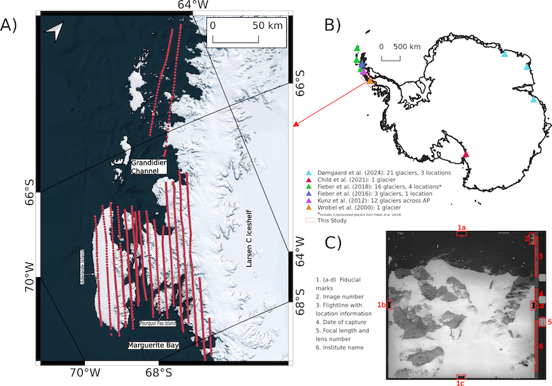
We present a unique, timestamped, high-resolution Digital Elevation Model (DEM) and orthomosaic dataset, derived from aerial imagery that covers about 12 000 km2 area on the western Antarctic Peninsula and surrounding islands between 66–68° S. We used a film-based aerial image archive from 1989 acquired by the Institut für Angewandte Geodäsie (IfAG), which is kept in the Archive for German Polar Research at the Alfred Wegener Institute, Germany, to generate the historical DEMs and orthoimages. The reference elevation model of Antarctica (REMA) mosaic is used as a reference DEM to co-register our historical product on stable ground. We evaluated the vertical accuracy of the derived IfAG DEM with independent surface elevation data from ICESat-2 from the summer months of 2020 and 2021. Our historical DEMs have vertical accuracies better than 6 and 8 m with respect to modern elevation data, REMA, and ICESat-2, respectively. The late 20th century DEM and orthomosaic are very valuable observations in a data sparse region, and this dataset will help to quantify historical ice volume changes and inform geodetic mass balance estimates. The dataset is publicly available at https://doi.org/10.5281/zenodo.17949026 (Thota et al., 2025) and the results presented in this paper are based on version 1.2 of the dataset.
Publication available on: https://doi.org/10.5194/essd-18-597-2026