SP1

SP1 SPs

SP1.1: A lightweight multifrequency radar system for snow and firn structure measurements

Subproject 1.1

A lightweight multifrequency radar system for snow and frin structure measurements

Typically ground-based GPR systems for geophysical applications consist of low frequency pulse radars that operate in the MHz frequency range. As those rudimentary radar concepts have proven to be easy to use and offer enough resilience to endure in rough environments in the past, the most recent and enormous advances in radar technology have almost exclusively been made in other fields such as automotive radar or personnel security scanner systems. Innovative GPR approaches can strongly benefit from these new radar techniques e.g. by multi-functional radar systems that utilize software-defined waveforms and measuring principles best adapted to the specific environment and measuring task.

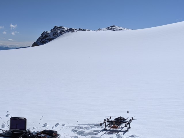
A holistic hardware-software design based on cutting-edge technology is needed to obtain the maximum performance for the intended field of use. By this, enhanced mapping and surveying of subglacial structures will be achieved, and previously unsolved challenges linked to the measurement of ice and snow parameters in remote locations will be effectively addressed. A lightweight and easy-to-transport radar system will be developed within this project which will serve as a versatile sensor setup for multiple applications in remote glacial environments. For this, a multifrequency system will be implemented which will make use of the benefits of different frequency bands. E.g., typical GPR systems for measuring ice sheet thicknesses on alpine glaciers operate in the sub 200-MHz region as signals experience less attenuation but can only obtain comparably small bandwidths and therefore low resolution. Imaging Radars working in the >1GHz frequency range suffer from higher attenuation but can reach an outstanding resolution. Those and further advantages will be combined for maximum performance and flexibility adapted to each scenario.

For this purpose, suitable high-performance and meanwhile power and weight-saving transceiver frontend concepts need to be designed and tested for their usability. Furthermore, innovative antenna concepts need to be examined in order to address the requirements of lightweight and small size while maintaining excellent radiation characteristics over a wide/multiband frequency range. With the integration of localization techniques such as differential GNSS and other advanced self-localization techniques, it will be possible to apply ground-based SAR techniques for enhanced resolution and sensitivity of the overall system. The integrated digital backend will exploit cutting-edge radar algorithms which have to be expanded in order to combine data taken in different frequency bands for extracting an even wider range of parameters from the surveyed ice structures compared to a single band evaluation.

Examples for those results are amongst other things estimated water content in the snow/firn cover or the glaciers permittivity profile which is directly linked to the ice density. Integrated into vehicles such as UAVs the system will be capable of surface-based mapping of large areas in a time and cost-effective manner. The system will be tested extensively on Vernagt- and Hintereisferner. This subproject will collaborate with SP1.2, 1.3, 2.3 and 3.1.


For specific information on the subproject please contact: Prof. Dr.-Ing. Martin Vossiek; Institute of Microwaves and Photonics (LHFT), Cauerstr. 9, 91058 Erlangen, T: 09131-85-20773, martin.vossiek@fau.de, https://www.lhft.eei.fau.de/

Co-PIs: G. Krieger (DLR HR), T. Seehaus (FAU Geography), F. Navarro (U. Madrid)


Get to know our project affiliated PhD students

Lena Krabbe

Lena Krabbe

lena.krabbe@fau.de

During my Master studies at FAU in the field of Electrical Engineering I specialized in radar technology which has various fields of application such as autonomous driving, industrial automation, and medical sensor technology.
Moreover, analyzing snow and ice structures of glaciers with radar is an extremely exciting and important application as we currently face challenges like climate change and environmental pollution.

During my PhD studies within the scope of the IDP M3OCCA I will develop a high performance, flexible and easy-to-transport radar system in order to retrieve detailed insights into glacial structures and their variations. In my free time I enjoy playing Volleyball, making music on my flute or guitar as well as working in my private garden at home or in the student garden at our faculty.

SP1 SPs

SP1.2: SAR tomography for 3D imaging of snow and firn structures

Subproject 1.2

SAR tomography for 3D imaging of snow and firn structures

Structures in the firn and snow cover on glaciers can be caused by annual melt/freeze cycles, but also by internal water percolation or refreezing. Additionally, water channels within the glaciers are important indicators for melt water routing in geophysical and hydrological glacier models. The highest changes occur within the upper layer (first tens of meters) and are therefore of importance to be monitored. Synthetic Aperture Radar (SAR) tomography is an evolving 3D imaging technique that enables the mapping of subsurface properties of glaciers and ice sheets with high spatial resolution, taking advantage of the penetration of radar signals up to several tens of meters into dry snow, firn, and ice (Tebaldini et al., 2016, Fischer et al., 2019). The main objective of this doctoral project is to exploit and improve this powerful 3D imaging technique and to establish the relation of the vertical reflectivities to geophysical snow/ice parameters. Moreover, new tomographic imaging modes and techniques like transmission, MIMO and subaperture-based tomography will be explored in view of their potential to gain further information about the internal structure and dielectric properties of snow and glaciers. In the frame of the project dedicated campaigns on Vernagtferner and Hintereisferner will be conducted, where multiple sensors collect data to estimate and characterise the internal structures of snow and ice regions. For this, the airborne multi-modal SAR system of DLR, as well as ground-based laser and radar systems will be deployed to acquire both multi-angular and multi-temporal data. Simultaneously, point/grid-based measurements and satellite data will be collected and evaluated. Strong links exist to SP1.1, SP1.3, SP2.2, SP2.3 and SP3.1.

For specific information on the sub-project please contact: Prof. Dr.-Ing. Gehard Krieger, LHFT, Institute of Microwaves and Photonics (LHFT), Cauerstr. 9, 91058 Erlangen, T: 08153-28-3054, gerhard.krieger@fau.de

Co-PIs: I. Hajnsek (DLR HR / ETH ZH), C. Mayer (BAdW), H. Rott (ENVEO IT)


Get to know our project affiliated PhD students

Patricia Schlenk

Patricia Schlenk

Patricia.Schlenk@dlr.de

I am a PhD student both at the German Aerospace Center (DLR) and the Friedrich-Alexander-Universität Erlangen-Nürnberg (FAU), being supervised by  Prof. Gerhard Krieger (FAU/DLR) and Prof. Irena Hajnsek (DLR).

I studied environmental engineering at the Technical University of Munich. Furthermore, I specialized in hydraulic engineering and water management as well as hydrology. The goal of my master thesis was to build, to adapt and to automate an existing Wet Snow Mapping Algorithm by Thomas Nagler in order to get detailed information about snow as well as glacier melt. This thesis really peaked my interest in SAR and snow/ glacier research and I believe to provide a contribution to the further development in this field of study.

In addition to my academic interests, I have always been interested in other cultures and foreign countries. I went to high school in the U.S. and New Zealand for a total of eight months, studied French for a year at the Université inter-âges in Paris, and spent a semester at the École polytechnique fédérale de Lausanne. I was able to put the experience and knowledge I gained during my time abroad to good use as a student representative and in my work at the TUM Center for Study and Teaching for five years. There I advised mostly international students on problems within their studies. The IDP M³OCCA with its interdisciplinary and international approach is an excellent continuation of my previous work.

SP1 SPs

SP1.3: Machine learning on radargrams

Subproject 1.3

Machine learning on radargrams

Information on ice thickness and internal structures of ice bodies (e.g. water table, isochrones, water pockets, and channels) from ground penetrating radargrams is to date often picked manually. Often only a specific target neglecting all other information is traced since existing contour-following algorithms in standard software like REFLEX do not provide consistent and reliable output. Within this doctoral project, we aim at using and modifying machine learning techniques from medical imaging as well as natural language processing (NLP) and apply those to glaciological radargrams. Ice thickness, bedrock topography, as well as internal structures, shall be mapped ideally at once after the respective pre-processing of the radargrams has occurred. Each radargram is composed of lines denoting different structures in the ice body. Algorithmically, this represents a segmentation problem in radargrams.
Datasets are available from airborne and ground-based low-frequency radar surveys of sites in the Alps and high Mountain Asia (BAdW), planned campaigns in Patagonia and alpine-type glaciers in Antarctica (FAU). Additional material for algorithm testing and training is available through an intense collaboration with AWI from polar surveys. Ideally, the developed algorithms will also be tested on the first survey data of the developed new multi-frequent radar in sub-project 1.1. Further links exist also to SP 2.3, and 3.1.

Co-PIs: A. Maier (FAU Informatics), T. Seehaus (FAU Geography), F. Navarro (U. Madrid)


Get to know our project affiliated PhD students


Marcel Dreier

Marcel Dreier

marcel.dreier@fau.de

Hi, I am Marcel, and I studied Computer Science at Friedrich-Alexander-Universität Erlangen Nürnberg. I finished my master’s degree in August 2023, and I am currently a PhD student at the Pattern Recognition Lab at Friedrich-Alexander-Universität Erlangen Nürnberg under the supervision of Prof. Andreas Maier.
My research in the M3OCCA project focuses on the segmentation of glacier radar images using deep learning. Since glacier radar images are usually segmented by hand, geographers spend many hours dividing the glacier into different sections. Especially with the increase in data in recent years, this task has become very expensive. Hence, my research aims to alleviate that problem by using deep learning to speed up and automate the segmentation of glacier radargrams.
In my free time, I enjoy going for walks and bouldering.